
Introduction
Offshore rigs and platforms were constructed to serve the nation’s oil and gas industry as early as the 1960s. In 2017, the oil and gas industry contributed about 14.5% of the gross domestic product (The Star, 2017). After servicing the industry for more than half a century, about 51% of the offshore rigs and platforms have exceeded their design lifespan and are identified as decommissioning candidates.
Malaysia has roughly 300 shallow water fixed oil and gas platforms operated by various operators in three regions: namely, Peninsular Malaysia Operation, Sarawak Operation (SKO), and Sabah Operation. Most of these platforms are shallow water platforms which are especially appropriate for Peninsular Malaysia waters, where water depths range from 50–70 m. Many of these platforms are over 20 years of age and 48% of the platforms have exceeded their 25-year design life. About 28% of these platforms are located off Sarawak shores, 12% off Sabah’s, and the remaining 8% off Peninsular Malaysia’s (Vahrenkamp et al., 2005). The decommissioning activities for fixed offshore platforms in Malaysia are expected to increase significantly. Thus far, only a handful of offshore platforms in Malaysian waters have been decommissioned mainly due to a lack of regulatory framework and weak decommissioning plans (Zawawi & El-Sayed, 2012).
Despite international legislation concerning procedures for offshore oil and gas platforms decommissioning such as the 1958 Geneva Convention on the Continental Shelf, the 1982 United Nations Law of the Sea Convention (UNCLOS), and the 1989 International Maritime Organization (IMO) Guidelines and Standards, there are little international consensuses on best practices for decommissioning (Macreadie et al., 2011). The concept/program of rigs-to-reefs (RTR) was then developed into one of the alternatives for complete deconstruction and removal of the installation and associated components of offshore oil and gas platforms (Hamzah, 2003).
The RTR program was originally proposed by the Bureau of Safety and Environmental Enforcement in 1984. Around an aging structure, a plethora of aquatic life begins to colonize the structure, resulting in the creation of artificial reefs (AR) that support the marine ecosystem and in turn industries such as scuba diving and fishing. However, not all platforms are suitable as reefing candidates, and for any platform to be considered for reefing, it must first undergo extensive ecological evaluations to assess any potential value it might add to the local ecosystem.
The RTR concept/program is deemed a “win-win” premise, whereby obsolete rigs are recycled and turned into AR for benthic habitat conservation and fishery management; and provide substantial cost savings for the oil and gas industry (Zawawi & El-Sayed, 2012).
Nevertheless, the RTR concept draws support and critics from various parties. The debate is focused on whether the structures or facilities left in place or like an AR habitat constitute valuable habitat and deliver ecosystem services, or in contrast, impact the environment and thus should be removed. Some offshore facilities, although deployed as AR for a very long time, have not developed the diversity of benthic or fish assemblages comparable to that found on natural reefs (Schroeder & Love, 2004). Southeast Asia hosts many aging offshore facilities and the shortage of decommissioning yards, and the lack of policy framework and financial support prohibit these activities to be conducted in a way that safeguards the environment and the biodiversity of the marine environment.
In addition, coral larvae present in planktonic form were dispersed by the sea currents after spawning. When the environmental condition becomes favorable, these larvae will settle down and develop into new reefs. In principle, by over-laying information of the 1) environmental conditions, 2) current circulation pattern, 3) understanding of reef connectivity between nearshore and offshore coral reefs, and the pattern of spawning season/timing in the southern South China Sea, a spatial “reefing viability index” can be developed to evaluate the chance of successful reefing in the offshore environment.
The objective of this study is to have a better understanding of the impact of the PETRONAS oil and gas platform on commercial fisheries activities, which with the findings in the “reefing viability index” will help to inform PETRONAS’s future decommissioning decisions. This study will assess the potential reefing area of the Malaysian offshore environment and may help determine if the design and proposed locations for future RTR candidates would benefit commercial fishing groups, further qualifying them as appropriate AR candidates as well as on potential as a new fishing ground.
Materials and Methods
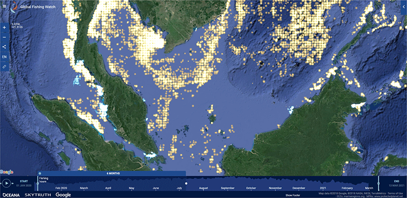
Google’s Global Fishing Watch (GFW) technology is one of the applications to measure commercial fishing efforts around the globe. Using data collected from satellite and terrestrial receivers, GFW tracks commercial fishing vessels using computer algorithms that learn and identify commercial fishing patterns and enable an evaluation of the apparent commercial fishing activity. By analyzing these patterns, Universiti Malaysia Terengganu (UMT) evaluated apparent commercial fisheries activity in the area surrounding a selected twelve PETRONAS platforms in Peninsular Malaysia Asset (PMA), Sabah Asset (SBA), and SKO region. The generated of digitized maps using the National Institute of Statistics and Geography Imagery (INEGI) from the National Aeronautics and Space Administration (NASA) copyright to evaluate apparent commercial fishing activities around PETRONAS platforms. The data were collected and gathered from the automatic identification system (AIS) by satellite and terrestrial areas from sensors of commercial fishing vessels. Additionally, the employment of the visible infrared imaging radiometer suite (VIIRS), a boat detecting system that has the capability of producing high-resolution and precise data from sea surfaces, is considered.
VIIRS detects night-time light emissions from fishing vessels and was included to capture apparent commercial fishing activity from vessels lacking AIS (e.g., commercial vessels < 300 gross tons [IMO, 1998]). When combined into a digital map, these data sets can be used to demonstrate areas of significant apparent commercial fishing activity over time.
UMT used these data sets to observe apparent commercial fishing activity and count all vessels exhibiting apparent fishing behavior within a 5-nautical mile (nmi) radius around each platform from January 2012 through December 2018. For the analysis described in this report, we assume that the vessels within a radius of 5 nmi are considered ‘near’ to the site. Vessels that were outside of this 5-nmi radius are not considered to be within the nearby area of the sites. The apparent commercial fishing effort around the selected twelve PETRONAS platforms was analyzed from January 2012 to December 2018 for AIS broadcasting vessels. VIIRS was unavailable on GFW before 2016, therefore VIIRS detections could only be analyzed from January 2016 to December 2018. Due to a lack of reliable records of recreational fishing activity and the absence of vessel-tracking technology on recreational vessels, recreational, and artisanal fishing efforts around selected twelve PETRONAS platforms were not assessed.
The existing oil and gas platforms have been utilized by fishermen and anglers for fishing activities. The activity is one of the important factors in terms of food security and socio-economic and national economic growth. In Malaysia, the fishing zonal division was divided into 5 zones which are zone A, B, C, C2, and C3 (Official Portal Department of Fisheries Malaysia, Ministry of Agriculture and Food Industry, 2021; Mat Piah et al., 2018). Fishing zone A is mostly operated by traditional fishermen. As for zone C2, most of the fishing vessels operating in the area are trawlers and purse seiners. However, a fishing vessel from zone B normally exceeds its boundary limitation to fish in zone C and C2. This is due to the abundance of resources available in the operation zone of oil and gas activity. The fishing activities usually happened around the oil platform but were limited to 500 m from the platforms.
In this study, we incorporated data from nightly satellites to investigate the fishing activity close to the oil platforms in Peninsular Malaysia, Sabah, and Sarawak. The data for night light vessel detections from the Global Fishing Watch database (https://globalfishingwatch.org/map/) were acquired from National Centers for Environmental Information (NOAA) website (NOAA, 2018). The data shows vessels at sea that satellites have detected by the light that they emit at night. This includes all vessels that emit a lot of light at night, including non-fishing vessels. However, most lights detected at sea at night come from commercial fishing vessels. The satellite makes a single over-pass across the entire planet every night, detecting lights not obscured by clouds and designed to give at least one observation globally every day. Because the vessels are detected solely based on light emission, we can detect individual vessels and even entire fishing fleets that are not broadcasting AIS and so are not represented in the AIS-based fishing activity layer. Lights from fixed offshore infrastructure and other non-vessel sources are excluded.
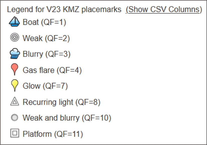
Fig. 1 shows the digital map for the night light vessel detection for South China Sea area, Peninsular Malaysia, Sarawak, and Sabah water, respectively. Night light detection consists of different types of light detected from boats, platforms, gas flares, and other vessels. In this report, we filtered and selected only reliable data specifically for commercial fishing boats, QF = 1 (Fig. 2). The QF = 1 data detection surpassed all VIIRS boat detection threshold tests which represent strong detection of the vessel. Commercial fishing activities in the range of 5 nautical miles (nm) surrounding the oil platforms were evaluated. The data acquired from NOAA for 3 years (2017, 2018, and 2019) were analyzed to identify the frequency of the commercial fishing activities at each platform.
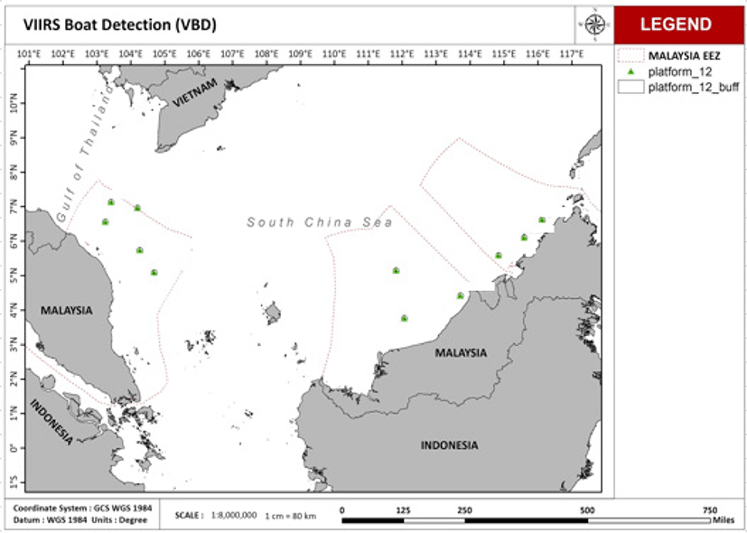
Twelve PETRONAS platforms were selected to study the vessel detection frequency around the platforms (Fig. 3). The data were extracted every month for the year 2016 to 2018 from the NOAA database. It can be seen in Table 1 that most of the selected platforms show a high frequency of vessels around the year.
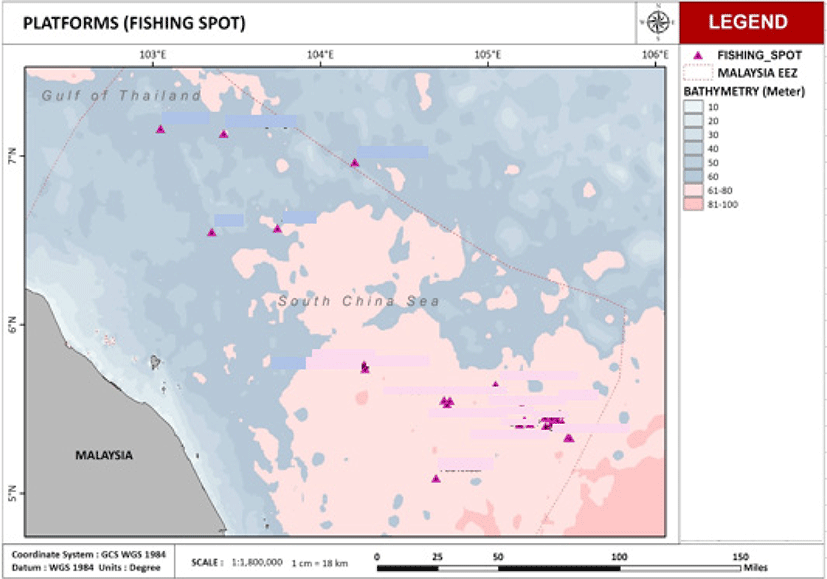
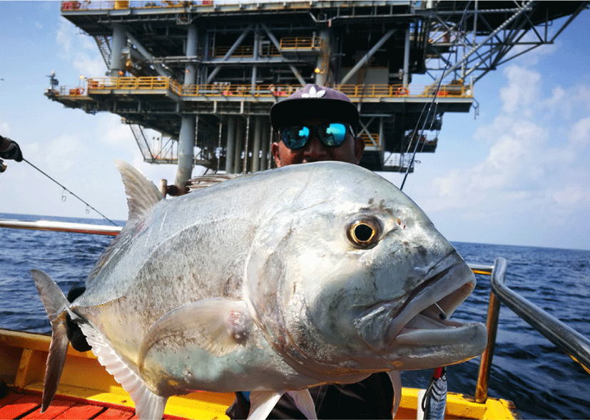
Sport fishing, also known as recreational fishing, is fishing for fun or competition. It differs from commercial fishing, which is done for profit, and subsistence fishing, which is done for survival. The most popular form of recreational fishing involves using a rod, reel, line, hooks, and any of a variety of baits. Other instruments, such as terminal tackle, are often used to influence or supplement the presentation of the bait to the target fish. The fisherman or anglers take advantage of the oil and gas platforms area which produce bigger fish compared to the coastal area. In this study, information about the regular fishing areas of the offshore recreational fishing groups from the Terengganu coast was collected through the recreational fishing group BlogSpot (Amang, 2018; PCL, 2016; Peacock, 2013). Information gathered included names, descriptions of the fishing areas, and photos of fish caught during the trip. The exact location (i.e., longitude and latitude) of the fishing spots were not provided by the fishing groups. Therefore, secondary data from the Global Fishing Watch database (https://globalfishingwatch.org/map/) were compiled with the information provided by the recreational fishing groups to illustrate the fishing activities around the oil platforms in the South China Sea. Fig. 4 shows the hot spot area for anglers in the PMA area. All spots were a close distance from the oil platforms. This is due to the majority of the deep-sea fish species residing around the platforms which act as an AR for the marine ecosystems.
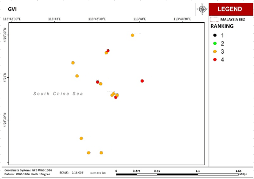
General visual inspection (GVI) is a visual assessment of the overall condition, followed by a report on the status of the structure. Using remotely operated underwater vehicle (ROV) along with video recording can do GVI effectively because ROV could fly past the structure, ensuring that it records 100% of the surface area (Thomsen, 2012). There are a few detections that GVI detected such as defects, biofouling, cracks, and discoloration. In addition, the GVI video data set provided an opportunity to examine the marine biodiversity richness underneath the platform. To assess the biodiversity, the benthic composition, and abundance, as well as the fish community, were quantified and then identified to the lowest data possible. After that, the platforms were ranked (from 1 to 4) accordingly to indicate the potential of these platforms for the RTR program.
The GVI video provided will first be screened and sorted according to region and cluster within the region, footage record method, as well as quantity and quality. The video will be analyzed in three sections which are: 1) benthic (such as the proportion of biological abundance, and marine invertebrate diversity), 2) fish biodiversity and 3) water clarity. Note that the water clarity is subjected to the time of the day in the GVI, i.e., video recorded at night will have lower visibility compared to daytime. After the analysis, the data will be used as the biological reef viability index (BRVI) and also identify new/potential sources of coral larvae. Validation with 181 GVI video analysis rank shows a good agreement on the output from the modeling approach.
The scope of work consists of the analysis of GVI and improvement of the BRVI model accuracy. The milestones are as follows:
-
Analysis of GVI video footage
-
Conduct a literature review on the BRVI and update the governing equations and cited references.
-
Consolidate the GVI footage and catalog the files in an organized manner.
-
Conduct verification analysis of the GVI videos as per the qualitative ROV validation assessment equation in the previous study.
-
Include an analysis on the classification of fish abundance and biomass assemblage in 3 specific locations which relate to reef fish, commercially important fish etc.
-
Conduct reiterative data analysis of up to 360 GVI footage.
-
Input new data points in BRVI accordingly.
-
Organize and supply the data in an editable format (doc, ppt, xlsx).
-
-
Replication of analysis for improved model accuracy
-
Close-out report
An inventory list of the GVI videos was generated after the first screening to ensure a systematic screening process without neglecting any pertinent data. From the inventory, 20% of the total numbers of rigs within each cluster were randomly selected and analyzed. This process was repeated until all GVI video footage are analyzed. Results were compiled and evaluated accordingly for simulation data verification to determine reefing viability. The method of widely used video transect for tropical coral reefs (Safuan et al., 2015) was adapted into the GVI video analysis of the benthic community. Initial screening of the videos was carried out to establish the general profile of the footage including:
-
Locations
-
Maximum water depth
-
Video quality and clarity
-
General coverage of marine growth
-
Identify interesting sections (e.g., close view of the structure or benthic) or similar/repetitive content
Information from the first screening was added to the inventory list for easy reference. This will help to maximize the time and effort spent on further analysis. The videos that passed initial screening were examined thoroughly to determine the benthic composition and density found on the rigs. The footage assessment involves pausing the video and a screenshot of 10 non-overlapping frames per video will be generated. In each frame, all benthic are observed and recorded with special attention to indicator/unique species (e.g., hard corals). However, due to the varying video quality, not every still image can provide a clear image. Highly indistinct images (e.g., too fuzzy, dark, far away from rig structure) were discarded. Therefore, the benthic organisms captured in the video were then identified down to the lowest taxonomy rank possible depending on the quality of the GVI videos.
Viable still images were imported to an image analysis software, Coral Point Count with Excel Extension (CPCe) by Kohler & Gill (2006) for the estimation of the benthic cover of a particular rig. Fifty grid points per frame were analyzed. From the results of CPCe analysis, five categories of benthic variables were assigned:
At each site/rig ROV videos were sampled (5 replicates) based on segmented depth/areas (i.e., 1 to 30 m, 31–60 m), making 10 replicates at each rig, where possible. At each replicate, the video was a freeze at the best and most diverse area for the highest possible diversity and biomass of fishes.
All species of fishes were identified to the lowest taxonomic level possible, based on the designated depth/areas from the ROV video provided from the respective rigs. All the species were identified to species level, according to established photographic field guides, such as Allen et al. (2003), Allen & Erdmann (2012), Matsunuma et al. (2011), and other relevant fish taxonomic publications. All commercial species observed from the videos have also been identified and counted, even though they are observed outside of the replicates. This is because commercial species are pelagic and not really site attached, with exception of several families, like the Groupers.
All fish species were identified and counted for each segment of rigs. The size of all fishes was estimated from the video provided in an estimation of 1 m square area. At each segment of 30 meters, 5 replicates of data were collected, to have a robust average estimate of the number of fishes and productivity per meter square area.
For effective data assimilation from the video input, there were certain requirements to be met in each category. A three-leveled rating method (good, moderate, and poor) was applied to fish, invertebrates, and water clarity. Due to the distinct characteristics of the reviewed components, a different set of assessment criteria was implemented for each category as shown in the Table 2. Note that the assessment criteria were created specifically for platform GVI video which varied in terms of a) low video quality especially old footage and video from divers, b) poor water condition (i.e., turbid water), and c) night footage which limits the visual distance, especially for the schooling of fish, and d) size of the marine animals. On the other hand, the rating criteria could be further refined once the mentioned limitations above have been improved through the improvement of survey hardware such as the use of high definition camera, the laser beam for measurement, proper lighting, and specific marine survey methodology.
The category of hard corals had a different rating strategy than fish, invertebrates, and water clarity. Corals were assessed based on their presence/absence at a platform during video screening. If found present, the coral was further separated into reef-forming hard corals (such as Pocillopora, Porites, etc.) or non-reef-forming corals like the Tubastrea sp. Confirmation of their presence at a particular platform would lead to further identification process until the genus level, whenever possible.
The assessment criteria of each category (hard corals, fish, invertebrates, benthic coverage, and water clarity) provided a guideline for a structured review process. A weighting and ranking system were created to integrate multiple factors of the reviewed platforms. The qualitative ratings of all four evaluated aspects were converted into numerical scores (Table 3) based on their ratings from the video assessment.
| Category | Fish/invertebrates/water clarity/benthic | Hard corals | ||||
|---|---|---|---|---|---|---|
| Rating | Good | Moderate | Poor | Reef forming type | Non-reef forming type | Not detected |
| Score | 3 | 2 | 1 | 2 | 1 | 0 |
Subsequently, numerical value (weightage) was allotted for each category to express its’ cumulative significance in the overall platform ranking (Table 4). Numerical scores for each data category were multiplied by its given weightage and the final weighted scores were summed for each platform. The equation below was used to compute the final ranking of each oil platform.
| Category | Weightage |
|---|---|
| Fish | 1 |
| Hard corals | 2 |
| Invertebrates | 1 |
| Benthic coverage | 1 |
| Water clarity | 0.5 |
As illustrated in Table 4, the category of hard corals was assigned a higher weightage value than the others. This is due to the important role of hard corals as the backbone of a reef ecosystem. Hard corals are commonly used as indicator species in a coral reef health assessment. On the other hand, water clarity (abiotic factor) was allocated the least weightage value because of its relatively less significant impact on the other more weighted biological counterparts. Fish, invertebrates, and benthic coverage which comprised most of the reef organisms had the intermediate weightage value of 1 each. In addition, the weighting system developed for this study could represent each category’s contribution to the possibility of reef development in an offshore environment. The ranking system for the oil platforms was an effective analytical approach to transforming qualitative video data into the numerical evaluation of biodiversity and subsequently, the potential sites for in situ reefing (Table 5).
| Percentage (%) | Rank | Biodiversity | Reefing viability |
|---|---|---|---|
| 0–40 | 1 | Poor | Unlikely |
| 40–64 | 2 | Fair | Fair |
| 65–84 | 3 | Good | Potential |
| 85–100 | 4 | Excellent | Highly potential |
The percent value for ranking in Table 5, with 5%–6% lower in the percentile for Rank 2–4. The revised ranking value is mainly due to the updated “hard coral” assessment criteria (Table 3). The observation of either reef-forming hard coral or non-reef forming Tubastrea sp. was sufficient to show habitat-forming at the rig, and when coupled with a “good” rating for the remaining assessment criteria will indicate the “high potential” for reefing. In another scenario, if a platform was observed to have only non-reef forming Tubastrea and with a moderate rating for the rest of the assessment criteria would be achieving a minimum percentage for Rank 3 (Table 5).
Using the GVI video, all fish species were identified and counted for each segment of the platforms. The size of all fishes was estimated from the video provided in the estimation of 1 m2 area. Five replicates of data were collected from two depths (< 30 m and > 30 m) in each platform to have a robust average estimate of the number of fishes per m2 area. Fish biodiversity data were then classified further in reef fishes to look at fish guilds, such as commercially important fishes, reef fishes, and others.
The fish biomass was estimated based on individual fish size estimated. The weight of individual fish was estimated based on the weight-length relationship (Froese & Pauly, 2009) formula that was proposed by (Le Cren, 1951):
where, W = weight of fish (g), L is observed total length (cm), a is the regression intercept and b is the regression slope. “a” and “b” values were obtained for specific species from the global fish database: FishBase (Binohlan & Pauly, 1998). If no specific equation is available, an equation of similar species or genus, family, or body shape equations was applied. If no specific equation was available, an equation of similar species or genus, family, or body shape equations was applied. In the study, the biomass of fish on the rigs was referred to as biomass density (in g · m2) and the average biomass of fish was then obtained for each rig. Fish biodiversity data was later classified further in reef fishes to look at fish guilds, such as commercially important fishes, reef fishes, and others for further analysis and comparisons of rigs.
The price (RM/kg) of the commercial fish species recorded at the platforms was estimated following available data from the Official Portal Fisheries Development Authority of Malaysia, Ministry of Agriculture and Food Industries (2021), and selling price from a local market. Note that not all species were readily available from both sources mentioned here therefore the price was estimated according to the same genus/family of the fishes.
Results
There was limited to no commercial fishing pressure detected from vessels broadcasting either AIS or VIIRS observed surrounding platform MQ-A. VIIRS vessel detections showed several fishing pressures between January 2016 to December 2018 (n = 18), with a peak in vessel detections (n = 8) occurring from April through June of 2018, again during the most active season for offshore fishing activity in the South China Sea (SCS) (Teh et al., 2007).
There was limited to no commercial fishing pressure from AIS broadcasting vessels observed in the vicinity (defined as < 50 nautical miles) of the KP-A platform. In contrast, VIIRS data recorded numerous vessel detections (n = 584) between January 2016 to December 2018 near (defined as ≤ 5 nautical miles) platform KP-A, with observations of increased fishing activity (February–June 2016, March–July 2017, and March–June 2018), coinciding with the most active season for offshore fishing activity in the SCS (March–June; [Teh et al., 2007]).
There was limited to no commercial fishing pressure detected from vessels broadcasting either AIS or VIIRS observed surrounding platform TT-C. VIIRS vessel detections showed some fishing pressure between January 2016 to December 2018 (n = 91), with the highest in vessel detections (n = 5) occurring in July 2016, (n = 7) occurring in May 2017, (n = 7) occurring in August of 2018, again during the most active season for offshore fishing activity in the SCS (Teh et al., 2007).
There was limited to no commercial fishing pressure from AIS broadcasting vessels observed in the vicinity (defined as < 50 nautical miles) of the ST-B platform. In contrast, VIIRS data recorded numerous vessel detections (n = 210) between January 2016 to December 2018 near (defined as ≤ 5 nautical miles) ST-B, with observations of increased fishing activity (May–July 2016, April–August 2017, and May–September 2018), coinciding with the most active season for offshore fishing activity in the SCS (March–June; [Teh et al., 2007]).
There was limited to no commercial fishing pressure detected from vessels broadcasting either AIS or VIIRS observed surrounding platform SK-A. VIIRS vessel detections showed several fishing pressures between January 2016 to December 2018 (n = 24), with the highest in vessel detections (n = 4) occurring in January of 2016, several boats detection in every month of 2018 (January–June 2018) again during the most active season for offshore fishing activity in the SCS (Teh et al., 2007).
There was limited to no commercial fishing pressure detected from vessels broadcasting either AIS or VIIRS observed surrounding platform DP-A. VIIRS vessel detections showed some fishing pressure between January 2016 to December 2018 (n = 47), with a peak in vessel detections (n = 13) occurring from January through April of 2016, (n = 3) occurring in August 2017, and May–December 2018, again during the most active season for offshore fishing activity in the SCS (Teh et al., 2007).
There was limited to no commercial fishing pressure from AIS broadcasting vessels observed in the vicinity (defined as < 50 nautical miles) of the FO-A platform. In contrast, VIIRS data recorded numerous vessel detections (n = 282) between January 2016 to December 2018 near (defined as ≤ 5 nautical miles) platform FO-A, with observations of increased fishing activity (March–November 2016, May–November 2017, and April–December 2018), coinciding with the most active season for offshore fishing activity in the SCS (March–June; [Teh et al., 2007]).
There was limited to no commercial fishing pressure from AIS broadcasting vessels observed in the vicinity (defined as < 50 nautical miles) of the BG-A platform. In contrast, VIIRS data recorded numerous vessel detections (n = 464) between January 2016 to December 2018 near (defined as ≤ 5 nautical miles) platform BG-A, with observations of increased fishing activity (May–September 2016, April–December 2017, and every month of 2018), coinciding with the most active season for offshore fishing activity in the SCS (March–June; [Teh et al., 2007]).
There was limited to no commercial fishing pressure detected from vessels broadcasting either AIS or VIIRS observed surrounding platform SE-B. VIIRS vessel detections showed some fishing pressure between January 2016 to December 2018 (n = 200), with the highest in vessel detections (n = 68) occurring from March to November of 2016, (n = 63) occurring from February to November of 2017, March–May and October–November of 2018, again during the most active season for offshore fishing activity in the SCS (Teh et al., 2007).
There was limited to no commercial fishing pressure from AIS broadcasting vessels observed in the vicinity (defined as < 50 nautical miles) of the PL-B platform. In contrast, VIIRS data recorded numerous vessel detections (n = 355) between January 2016 to December 2018 near (defined as ≤ 5 nautical miles) platform PL-B, with observations of increased fishing activity (every month of 2016, February–December 2017, and March–August 2018), coinciding with the most active season for offshore fishing activity in the SCS (March–June; [Teh et al., 2007]).
There was limited to no commercial fishing pressure from AIS broadcasting vessels observed in the vicinity (defined as < 50 nautical miles) of the B-C platform. In contrast, VIIRS data recorded numerous vessel detections (n = 372) between January 2016 to December 2018 near (defined as ≤ 5 nautical miles) platform B-C, with observations of increased fishing activity January–May 2016 (peak [n = 56] in April), January–May 2017 (peak [n = 64] in March), and January–July 2018 (peak [n = 21] in April), coinciding with the most active season for offshore fishing activity in the SCS (March–June; [Teh et al., 2007]).
There was limited to no commercial fishing pressure detected from vessels broadcasting either AIS or VIIRS observed surrounding the B-B platform. VIIRS vessel detections showed some fishing pressure between January 2016 to December 2018 (n = 135), with the highest in vessel detections (n = 9) occurring in October of 2016, (n = 17) occurring in September of 2017, (n = 12) occurring in October and November of 2018, again during the most active season for offshore fishing activity in the SCS (Teh et al., 2007).
In this study, data derived from satellite imagery by detecting the night light emitted by any boat or ship using the VIIRS and Global Fishing Watch database were compiled to demonstrate the fishing activities around the oil platforms in the South China Sea. Fig. 4 shows the hot spot area for anglers in the PMA area. All spots were a close distance from the oil platforms. This is due to the majority of the deep-sea fish species residing around the platforms which act as AR for the marine ecosystems.
The fishing activity in the oil and gas platform area is one of the attractions to the anglers. Over the year, such activity shows an increasing trend. The collection of digital proof from anglers clearly shows the proximity of the activity to the offshore platforms (Fig. 5).
This is an unprecedented approach undertaken in this study to estimate the value of commercial fish at oil platforms. It is clearly elucidating the regular visit of recreational fishers at and/or around the platforms due to the biodiversity richness (in fisheries) underneath the sea. To further quantify the monetary value of fisheries resources, eight platforms were selected across different regions (i.e., PMA, SBA, and SKO) to identify commercial fishes found there and then estimate the value of the fishes. It is important to note that the fish data were extracted from the GVI video. Hence, the data output presented here is limited to the quality of the footage, the distance between the camera and the fishes, and the camera angle. The determination of quantity and size was done at the best estimation possible by looking at the size of any structure that exists in the video frame because no scale bar was provided in the GVI video.
The estimated values of commercial fishes varied between platforms, with ranged from RM 10,209.92 to RM 89,023.78 (Table 1). Among these platforms, the highest fish monetary value was recorded at platform JP-A followed by platform TT-3 with over RM 80,000. On the opposite, two platforms (platform EV-A and platform TP-A) were found to have about one-fifth of the highest monetary value platforms. The occurrence of large schooling high-value pelagic fish species like the Trevally (Caranx sexfacsiatus, Caranx ignobilis), Snappers (Lutjanus spp.), and Amberjack (Seriola dumerili), large demersal fish species such as Grouper (Epinephelus spp.) and also the large school of common Fusilier (Caesio spp.) contributed significant monetary values to the platforms.
When we crossed check these platforms with the GVI video analysis ranking, all these selected platforms were Rank 3 and 4 platforms which suggested good candidates for in-situ reefing. The data presented here echoing the existing additional value of the platform from the fisheries resources perspective. These resources, if manage in a sustainable manner can be served as 1) income generation for local fishermen, 2) food security for the country, and 3) conservation of important fish species for the future. Thus, platforms with high commercial fish value, if selected for reefing in-situ will serve for multi-purposes and benefit the locals as well as the country.
An area is considered nearshore with most of the platforms including in the GVI video analysis located within 35 km from the coastline. Also, the A platforms are near (~50 km) to Miri-Sibuti National Park which has good natural coral reefs. Platforms that are located near the natural coral reefs are predicted to have similar benthic communities and abundance with the natural reefs because of the similar environment and connectivity between them. GVI ranks are shown in Fig. 6 where the platforms are mostly ranked 3 and 4.
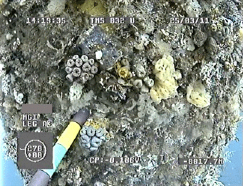
The abundance in benthic communities of the 15 platforms analyzed at A was varied (Table 6). On average, the GVI video analysis found that 11.14% of the platforms’ structures in A areas were covered with hard corals (reef- and non-reef building corals) (Fig. 7). The highest percent of hard coral (24.97%) was recorded on platform TQ-A while the lowest hard coral abundance (3.32%) was observed on platform TV-A. In contrast, platform TT-D platform was found to have about one-third covered in soft coral, but only a small amount (3.04%) of soft coral was recorded at platform TV-B. Similarly, the various sponge, mollusks, and other shells growing extensively on under the underwater jacket legs span from shallow to deep water (Fig. 8). The observation suggests that the environmental condition (such as water quality) at A is ideal for the marine communities to flourish. This also indicates that there is potentially well-established biological connectivity between the platforms and natural reefs. On the flip side, the marine invasive species (e.g., Carijoa riisei) which are found in abundance at offshore platforms may be easily dispersed to the nearshore natural reefs.
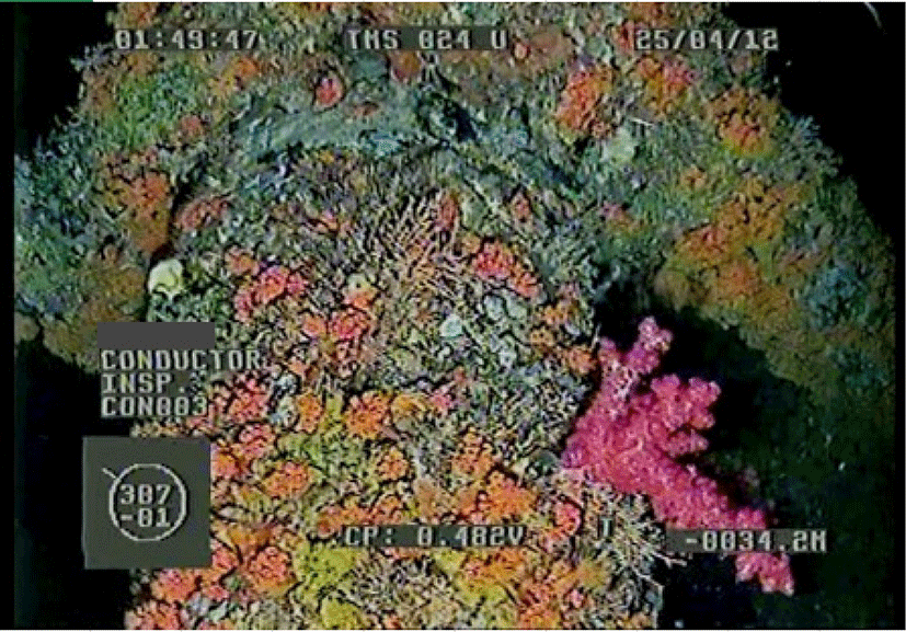
Platforms at A are highly valuable. It is estimated that one of the A areas (i.e., platform TT-3) could hold an estimation of RM 82,138.58 worth of fisheries resources, the top two most valuable (in fisheries resources) according to data from this project. Commercial fishes such as Amberjacks, Trevally, Groupers, Sweetlips, and Rainbow runner can be seen in abundance around A platforms. Other than that, coral reefs-associate fishes were also commonly sighted in the GVI videos (Fig. 9). This is another evidence of a good ecosystem developed beneath the platforms. This ecosystem could serve as refugia for the nearshore or shallow natural reefs which are more susceptible to anthropogenic impacts such as pollution and unsustainable development.

The platforms at A are good candidates for in-situ reefing. Indeed, out of the 15 platforms analyzed, 27% is highly potential (Rank 4) for in-situ reefing and the remaining platforms achieved a Rank 3 rating (Table 6). During the decommissioning process, an area potentially can be gazette as a marine protected area (MPA) such as the Satang-Talang National Park. The existing rich benthic biodiversity provides crucial habitat for marine organisms to take shelter. Over time, the expansion of marine organisms like the fishes within the MPA will create a spill-over effect recuperating area outside the MPA which has been subjected to human exploitation.
Discussion
The limited apparent commercial fishing effort detected around selected twelve PETRONAS platforms in PMA, SBA, and SKO region is likely due to two factors. First, both platforms are located > 130 nautical miles from shore and this distance may be a deterrent for fishermen who seek to concentrate their efforts on fisheries resources closer to shore. Second, because UMT’s assessment relied exclusively on AIS and VIIRS data available on GFW, it is unlikely that this analysis captured all apparent fishing efforts present around these platforms. Malaysian vessel monitoring system (VMS), a vessel-tracking technology required on commercial vessels operating in the Malaysian exclusive economic zone and deep-sea vessels above 70 gross registered tonnages, data is currently unavailable on GFW and therefore could not be incorporated into the commercial fisheries analysis.
The addition of Malaysian VMS data would provide a more comprehensive assessment of concentrated fishing effort around the selected twelve PETRONAS platforms. Despite these limitations, fishing vessels were detected near selected twelve PETRONAS platforms which indicates that fisheries stakeholders are actively utilizing the fishery resources associated with these platforms.
Conclusion
Based on this study, the commercial fishery assessments of Malaysian water offshore structures are investigated. To assess the potential of recreation fisheries offshore, the commercial assessment for sport fishing in the platform area was also conducted in the study via quantification of fishing vessels within 5 nautical miles from the platforms by using the AIS for commercial fishing vessels and VIIRS boat detection technology; and assessment of the site potential by interviewing major fishing trip operators in the PMA, SBA and SKO area. Results revealed that platforms with a higher reef viability index area have popular locations for recreational fishers. The fishing trip operators are also unanimously in favor of in-situ reefing, the reefing area is highly potential for the emergence of a high-end recreational fishing industry in the area.
Outputs/observations from the current study meet the aspiration of the government to develop new habitats that could be used as breeding and feeding grounds for marine demersal fishes. The new habitats could serve as a triggering point to revolutionize the fisheries industry for the country, and potential as a new fishing ground. Off the 181 platforms analyzed, over half of the platforms were found to have good biodiversity and potential for in-situ reefing purposes. Validation with 181 GVI video analysis rank shows a good agreement on the output from the modeling approach.
The current study has successfully assessed the potential reefing area of the Malaysian offshore environment with greater representativeness. Outputs from the RVI shall be able used for rapid screening and preparation of a sustainable management framework for the RTR program in the area. From the output results, the estimated values of commercial fishes varied between platforms, with ranged from RM 10,209.92 to RM 89,023.78. Thus, platforms with high commercial fish value, if selected for reefing in-situ will serve multi-purposes and benefit the locals as well as the country. The RVI is also subjected to a few technical limitations and challenges, which may lead to variation in the field. Hence, a more in-depth investigation and field assessment are needed to further verify the status of the offshore platforms in terms of their biological significance.